|
The increasing availability of non-traditional data for transportation planning provides enormous opportunities to greatly improve the way we analyze and model transportation patterns and systems in cities. The record high mobile phone penetration rate in many countries across the globe and availability of privacy-aware (or privacy-protective) techniques allow scientists, engineers, and planners to extract useful information from mobile phones for many applications including transportation planning. Mobile phone use data can work as rich supplementary data to traditional survey-based data commonly used in urban and transportation planning. Since 1960's, travel demand models have been developed to tackle urban transportation issues and to evaluate the impact of various planning scenarios and policies on how people travel in a city. More recently, activity- and agent-based models of travel demand, still mainly based on large and expensive survey-based data, are developed to help understand mechanisms underlying travel choices in their spatial context at the most disaggregate level possible. The next generation of travel demand models will take advantage of growing availability of mobile phone use data, GPS tracks, transactions data, and online activity patterns of individuals to predict and evaluate how people move around a city and interact with different places (people-place interaction). Mobile phone use data also provides economic value by creating a new data market for various businesses. When I first moved to Australia in 2014, I tried to establish relationships with main Australian mobile phone operators including Telstra and Optus and convince them to move toward commercialization of mobile phone use data while protecting privacy of their users. However, I was not successful (maybe with no surprise). AirSage (http://www.airsage.com/) is an example company in the US who "ANONYMOUSLY COLLECTS AND ANALYZES WIRELESS SIGNALING DATA – processing more than 15 billion mobile device locations everyday – turning them into meaningful and actionable information. As long as a mobile phone is active on the cellular network, AirSage receives wireless signals and uses them to anonymously determine location." 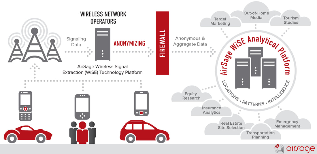 Image source: http://www.airsage.com/Technology/How-it-works/ Recently, a group of TRB committees focused on travel demand forecasting in collaboration with AirSage provided a unique opportunity to researchers to analyze multi-day travel demand in the form of origin-destination matrices gleaned from wireless signaling mobile data. The contest organizers invited short papers and supporting documents summarizing modeling or visualizations performed using the data. This was a great move towards promoting application of mobile phone use data in transportation and urban planning. Following is a visualization of origin-destination travel demand matrix in Orlando, Florida extracted from mobile phones provided by AirSage. Here, data is represented as a network (or graph) where nodes are origins and destinations and links represent trips between origin-destination pairs. Link colors represent number of trips between each origin-destination pair. Question: Now guess what the cluster of dark red links in the bottom left corner of the network represent? 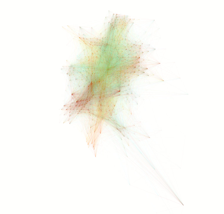 Answer: Disney World! and many other resorts, amusement and water parks are all located in this area.
If you are interested in the technical details and possible insights that one can get from analyzing such data representation, you can refer to my research laboratory website www.cityxlab.com or view some of the recent publications of Prof. Marta González from MIT (http://humnetlab.mit.edu/wordpress/) who is also an active researcher in this area. Special thanks to AirSage for providing the data as part of the TRB Data Analytics Contest and my PhD student Ziyuan Gu for analyzing and visualizing the data.
1 Comment
|
AuthorDr. Meead Saberi, lecturer in transportation engineering, data guru, and urban scientist Archives
August 2017
Categories |
 RSS Feed